5 Picking a Model
The VisionEval system is comprised of three models:
- VERSPM (VisionEval Regional Strategic Planning Model) was developed by Oregon Department of Transportation (ODOT) as an offshoot of the GreenSTEP model to support the preparation of metropolitan area scenario plans. The name reflects a broadening of the policies, beyond state statutory requirements. This model operates largely at the zonal level (i.e. inputs and outputs are zone-based).
- VE-State is a state level version of VERSPM. Like VERSPM, this model operates at the zonal level, but the zones are larger than their VERSPM counterparts.
- VERPAT (VisionEval Rapid Policy Analysis Tool) was developed under the federal Strategic Highway Research Program (SHRP2). The model was developed to help planners evaluate the potential effect of growth policies on regional travel. Portions of the GreenSTEP model were used in VERPAT, but substantial revisions were made to the code, including use of land use place type categories. This model operates largely at the region or place type level for the entire region.
5.1 Spatial Detail
One key distinction between the all VisionEval models is the level of spatial detail. In general, the VisionEval models with a greater level of spatial detail also require more effort for developing the model inputs. In picking a model, users should consider their needs in the context of this trade-off between spatial detail and development effort.
VERSPM was developed as a regional model for regional planning areas and MPOs. VERSPM models the region in zones (in a manner similar to traditional travel model zones), which results in improved spatial resolution of outputs, but which also increases the data development burden. The selection of the right tool therefore depends on a number of factors – available of data, project resources, desired spatial output detail, etc. Take a look at the model inputs, which has many inputs by Bzones.
VE-State was developed as an extension of the VERSPM model to enables users to apply the model for statewide applications. The main difference between the VERSPM and VE-State models is that a number of VERSPM inputs are specified at the Bzone level. Examples include numbers of dwelling units by type and numbers of jobs by sector. VE-State models run at a higher level of abstraction than VERSPM models and don’t have Bzone level inputs. Instead, the VE-State uses a process to synthesis Bzones.
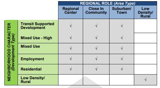
VERPAT, like VERSPM, operates primarily at the region level. However, VERPAT has less spatial detail than VERSPM and requires inputs at place type level. As shown below, place types are defined as a combination of area type and development type. Area type (or regional role) describes the interdependencies of each neighborhood compared to the rest of the region, e.g. how centered is it to jobs in the region. Development type (or neighborhood character) is used to describe the physical characteristics of each neighborhood in isolation. Operating at the place type level simplifies the input data requirements and the spatial precision of outputs while still capturing the effects of the different place types in the region. Take a look at the model inputs, which has only one input by Bzone (i.e., population and employment) which represents population and employment for each place type.